class: center, middle, inverse, title-slide .title[ # Spatial Visualization ] .author[ ### Thiyanga S. Talagala ] --- ### R packages for spatial data analysis .pull-left[ - rgdal - sp - rgeos - raster - sf - tmap - leaflet - ggmap ] .pull-right[ - maptools - gstat - spatstat - stars - geosphere - RgoogleMaps - rasterVis ] --- <!--https://www.earthdatascience.org/courses/earth-analytics/spatial-data-r/intro-vector-data-r/--> ### Geospatial vector data structures **Point:** Individual longitude and latitude of locations Eg: Locations, Buildings **Lines:** Two or more vertices or points that are connected Eg: Roads, rivers **Polygons:** Three or more vertices and closed Eg: Area of a country, state, district --- .pull-left[ **What do we want to plot?** Globe - 3D  ] -- .pull-right[ **Where do we plot?** Computer screen or paper - 2D <!-- --> ] --- class: center, middle, inverse # Challenge ## How to transform this three dimensional angular system to a two dimensional cartesian system? -- > Solution : Spatial projection <!--https://rspatial.org/raster/spatial/6-crs.html--> --- <!--https://docs.qgis.org/3.28/en/docs/gentle_gis_introduction/coordinate_reference_systems.html--> ## Types of map projections - Cylindrical projections - Conical projections - Planar projections > Visit [here](https://johnedevans.files.wordpress.com/2019/01/map-projections-explained.jpg) to see the visual illustration. --- ## **C**oordinate **R**eference **S**ystem (**CRS**) <!--are used to convert locations on the 3D globe, to a 2D cartesian plane--> Different types of CRSs: - Mercator - UTM - Robinson - Lambert - Sinusoidal - Alber --- <!--https://rpubs.com/mdavril_gsu/794598--> <!-- --> --- <!-- --> --- <!-- --> --- <!-- --> --- ### Why some areas are stretched and some areas are compressed? Projecting data from a 3D round surface onto a 2D flat surface results in visual modifications to the data. -- ### Why multiple CRS? To optimize to best represent the: shape distance area direction --- ## Shapefiles - Spatial data in vector format are often stored in a shapefile format - The structure of points, lines, and polygons are different, each individual shapefile can only contain one vector type (all points, all lines or all polygons). - You will not find a mixture of point, line and polygon objects in a single shapefile. - Shapefiles contain geographic vector data that is expressed in a particular CRS --- - A shapefile is made up of three required files with the same prefix ('spatial-data' in this case) but different extensions: **spatial-data.shp:** main file that stores records of each shape geometries **spatial-data.shx:** index of how the geometries in the main file relate to one-another **spatial-data.dbf:** attributes of each record --- ## CRS - geodetic datum (e.g, WGS84) - the type of map projection (e.g., Mercator) - the parameters of the projection (e.g., location of the origin) --- ## Two types of maps 1. Simple feature map 2. Polygon maps --- class: center, middle # Simple feature map --- ## Example ```r # install.packages("devtools") devtools::install_github("thiyangt/ceylon") library(ceylon) library(tidyverse) library(sp) library(viridis) ``` ```r data(sf_sl_0) class(sf_sl_0) ``` ``` ## [1] "sf" "tbl_df" "tbl" "data.frame" ``` ```r # work with spatial data; sp package will load with rgdal. library(rgdal) ``` ``` ## Please note that rgdal will be retired during October 2023, ## plan transition to sf/stars/terra functions using GDAL and PROJ ## at your earliest convenience. ## See https://r-spatial.org/r/2023/05/15/evolution4.html and https://github.com/r-spatial/evolution ## rgdal: version: 1.6-7, (SVN revision 1203) ## Geospatial Data Abstraction Library extensions to R successfully loaded ## Loaded GDAL runtime: GDAL 3.4.2, released 2022/03/08 ## Path to GDAL shared files: /Library/Frameworks/R.framework/Versions/4.2/Resources/library/rgdal/gdal ## GDAL binary built with GEOS: FALSE ## Loaded PROJ runtime: Rel. 8.2.1, January 1st, 2022, [PJ_VERSION: 821] ## Path to PROJ shared files: /Library/Frameworks/R.framework/Versions/4.2/Resources/library/rgdal/proj ## PROJ CDN enabled: FALSE ## Linking to sp version:1.6-1 ## To mute warnings of possible GDAL/OSR exportToProj4() degradation, ## use options("rgdal_show_exportToProj4_warnings"="none") before loading sp or rgdal. ``` ```r # for metadata/attributes- vectors or rasters library(raster) ``` ``` ## ## Attaching package: 'raster' ``` ``` ## The following object is masked from 'package:dplyr': ## ## select ``` ```r crs(sf_sl_0) ``` ``` ## [1] "PROJCRS[\"SLD99 / Sri Lanka Grid 1999\",\n BASEGEOGCRS[\"SLD99\",\n DATUM[\"Sri Lanka Datum 1999\",\n ELLIPSOID[\"Everest 1830 (1937 Adjustment)\",6377276.345,300.8017,\n LENGTHUNIT[\"metre\",1]]],\n PRIMEM[\"Greenwich\",0,\n ANGLEUNIT[\"degree\",0.0174532925199433]],\n ID[\"EPSG\",5233]],\n CONVERSION[\"Sri Lanka Grid 1999\",\n METHOD[\"Transverse Mercator\",\n ID[\"EPSG\",9807]],\n PARAMETER[\"Latitude of natural origin\",7.00047152777778,\n ANGLEUNIT[\"degree\",0.0174532925199433],\n ID[\"EPSG\",8801]],\n PARAMETER[\"Longitude of natural origin\",80.7717130833333,\n ANGLEUNIT[\"degree\",0.0174532925199433],\n ID[\"EPSG\",8802]],\n PARAMETER[\"Scale factor at natural origin\",0.9999238418,\n SCALEUNIT[\"unity\",1],\n ID[\"EPSG\",8805]],\n PARAMETER[\"False easting\",500000,\n LENGTHUNIT[\"metre\",1],\n ID[\"EPSG\",8806]],\n PARAMETER[\"False northing\",500000,\n LENGTHUNIT[\"metre\",1],\n ID[\"EPSG\",8807]]],\n CS[Cartesian,2],\n AXIS[\"(E)\",east,\n ORDER[1],\n LENGTHUNIT[\"metre\",1]],\n AXIS[\"(N)\",north,\n ORDER[2],\n LENGTHUNIT[\"metre\",1]],\n USAGE[\n SCOPE[\"unknown\"],\n AREA[\"Sri Lanka - onshore\"],\n BBOX[5.86,79.64,9.88,81.95]],\n ID[\"EPSG\",5235]]" ``` --- ```r sf_sl_0 ``` ``` ## Simple feature collection with 1 feature and 1 field ## Geometry type: MULTIPOLYGON ## Dimension: XY ## Bounding box: xmin: 362203.3 ymin: 380301.9 xmax: 621918.1 ymax: 813560.9 ## Projected CRS: SLD99 / Sri Lanka Grid 1999 ## # A tibble: 1 × 2 ## geometry COUNTRY ## <MULTIPOLYGON [m]> <chr> ## 1 (((481925.5 381353.7, 481922.9 381350.3, 481919 381348.2, 481914.6 38… SRI LA… ``` --- ## 2. Visualizing using shapefiles: map of Sri Lanka ```r ggplot(sf_sl_0) + geom_sf() ``` 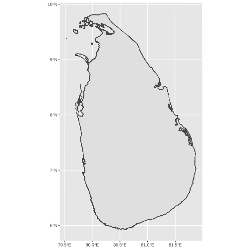<!-- --> --- ```r ggplot(sf_sl_0) + geom_sf(fill='beige') + theme_minimal() ``` 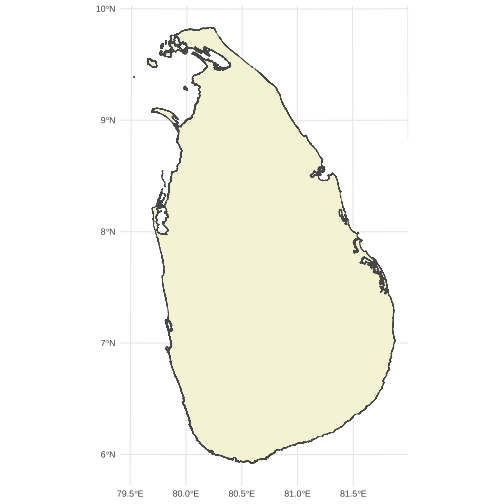<!-- --> --- ```r library(knitr) sf_sl_0 %>% kable() ``` |geometry |COUNTRY | |:------------------------------|:---------| |MULTIPOLYGON (((481925.5 38... |SRI LANKA | --- ## Your turn: Draw district and province maps data: ```r province district ``` --- .pull-left[ Province ```r ggplot(data=province) + geom_sf() ``` <!-- --> ] .pull-right[ District ```r ggplot(data=district) + geom_sf() ``` <!-- --> ] --- ```r province ``` ``` ## Simple feature collection with 9 features and 3 fields ## Geometry type: MULTIPOLYGON ## Dimension: XY ## Bounding box: xmin: 362203.3 ymin: 380301.9 xmax: 621918.1 ymax: 813560.9 ## Projected CRS: SLD99 / Sri Lanka Grid 1999 ## # A tibble: 9 × 4 ## geometry PROVINCE Status population ## * <MULTIPOLYGON [m]> <chr> <chr> <dbl> ## 1 (((498211.2 611042.6, 498401.7 610897.1, 498415.9 … CENTRAL Provi… 2781000 ## 2 (((609877 559315.9, 609857.5 559313, 609845.2 5593… EASTERN Provi… 1746000 ## 3 (((501928.5 712099.6, 501970.4 712098.8, 502020 71… NORTH C… Provi… 1386000 ## 4 (((393087.5 629959, 393098.1 629956.7, 393103.2 62… NORTH W… Provi… 2563000 ## 5 (((405858.7 700083.7, 405855.3 700082, 405851.5 70… NORTHERN Provi… 1152000 ## 6 (((432117.3 521875.5, 432083.5 521852.9, 432041.7 … SABARAG… Provi… 2070000 ## 7 (((481925.5 381353.7, 481922.9 381350.3, 481919 38… SOUTHERN Provi… 2669000 ## 8 (((522825 568220.9, 522872.6 568217.7, 522926.1 56… UVA Provi… 1387000 ## 9 (((411888.2 438189.4, 411886.4 438182.3, 411881.7 … WESTERN Provi… 6165000 ``` --- ```r district ``` ``` ## Simple feature collection with 26 features and 3 fields ## Geometry type: MULTIPOLYGON ## Dimension: XY ## Bounding box: xmin: 362203.3 ymin: 380301.9 xmax: 621918.1 ymax: 813560.9 ## Projected CRS: SLD99 / Sri Lanka Grid 1999 ## # A tibble: 26 × 4 ## geometry DISTRICT Status population ## * <MULTIPOLYGON [m]> <chr> <chr> <dbl> ## 1 (((392952.6 594064.2, 392985.8 593971.5, 392986.2… [UNKNOW… <NA> NA ## 2 (((551311.8 581603.6, 551324.5 581599.7, 551334.5… AMPARA Distr… 736000 ## 3 (((501928.5 712099.6, 501970.4 712098.8, 502020 7… ANURADH… Distr… 943000 ## 4 (((522825 568220.9, 522872.6 568217.7, 522926.1 5… BADULLA Distr… 886000 ## 5 (((609877 559315.9, 609857.5 559313, 609845.2 559… BATTICA… Distr… 579000 ## 6 (((400911.5 497888.4, 401032.5 497869.3, 401035.2… COLOMBO Distr… 2455000 ## 7 (((425038.8 404072.5, 425030.7 404072.5, 425022 4… GALLE Distr… 1135000 ## 8 (((430775.7 534473.9, 430789.2 534441.8, 430790.2… GAMPAHA Distr… 2423000 ## 9 (((592923.3 452679, 592949.2 452679, 592989.8 452… HAMBANT… Distr… 668000 ## 10 (((362968.6 763698.5, 362883.6 763686.9, 362787.9… JAFFNA Distr… 621000 ## # ℹ 16 more rows ``` --- ## Guess the output. ```r ggplot() + geom_sf(data=province, lwd=2, col="black") + geom_sf(data=district, linetype=21, col="red") ``` --- ## Your turn: Colour provinces according to the population. --- ## Annotations .pull-left[ ```r ggplot(sf_sl_0) + geom_sf(fill='beige') + ggspatial::annotation_north_arrow(location = "br")+ ggspatial::annotation_scale(location = "bl") ``` ] .pull-right[ <!-- --> ] --- ## More work <!--https://rpubs.com/Dr_Gurpreet/spatial_data_visualisation_R--> ```r library(spData) ``` ``` ## To access larger datasets in this package, install the spDataLarge ## package with: `install.packages('spDataLarge', ## repos='https://nowosad.github.io/drat/', type='source')` ``` ``` ## ## Attaching package: 'spData' ``` ``` ## The following object is masked _by_ '.GlobalEnv': ## ## world ``` --- ```r data("us_states") # from spData package us_states ``` ``` ## Simple feature collection with 49 features and 6 fields ## Geometry type: MULTIPOLYGON ## Dimension: XY ## Bounding box: xmin: -124.7042 ymin: 24.55868 xmax: -66.9824 ymax: 49.38436 ## Geodetic CRS: NAD83 ## First 10 features: ## GEOID NAME REGION AREA total_pop_10 total_pop_15 ## 1 01 Alabama South 133709.27 [km^2] 4712651 4830620 ## 2 04 Arizona West 295281.25 [km^2] 6246816 6641928 ## 3 08 Colorado West 269573.06 [km^2] 4887061 5278906 ## 4 09 Connecticut Norteast 12976.59 [km^2] 3545837 3593222 ## 5 12 Florida South 151052.01 [km^2] 18511620 19645772 ## 6 13 Georgia South 152725.21 [km^2] 9468815 10006693 ## 7 16 Idaho West 216512.66 [km^2] 1526797 1616547 ## 8 18 Indiana Midwest 93648.40 [km^2] 6417398 6568645 ## 9 20 Kansas Midwest 213037.08 [km^2] 2809329 2892987 ## 10 22 Louisiana South 122345.76 [km^2] 4429940 4625253 ## geometry ## 1 MULTIPOLYGON (((-88.20006 3... ## 2 MULTIPOLYGON (((-114.7196 3... ## 3 MULTIPOLYGON (((-109.0501 4... ## 4 MULTIPOLYGON (((-73.48731 4... ## 5 MULTIPOLYGON (((-81.81169 2... ## 6 MULTIPOLYGON (((-85.60516 3... ## 7 MULTIPOLYGON (((-116.916 45... ## 8 MULTIPOLYGON (((-87.52404 4... ## 9 MULTIPOLYGON (((-102.0517 4... ## 10 MULTIPOLYGON (((-92.01783 2... ``` --- ```r data("us_states") # from spData package us_states ``` ``` ## Simple feature collection with 49 features and 6 fields ## Geometry type: MULTIPOLYGON ## Dimension: XY ## Bounding box: xmin: -124.7042 ymin: 24.55868 xmax: -66.9824 ymax: 49.38436 ## Geodetic CRS: NAD83 ## First 10 features: ## GEOID NAME REGION AREA total_pop_10 total_pop_15 ## 1 01 Alabama South 133709.27 [km^2] 4712651 4830620 ## 2 04 Arizona West 295281.25 [km^2] 6246816 6641928 ## 3 08 Colorado West 269573.06 [km^2] 4887061 5278906 ## 4 09 Connecticut Norteast 12976.59 [km^2] 3545837 3593222 ## 5 12 Florida South 151052.01 [km^2] 18511620 19645772 ## 6 13 Georgia South 152725.21 [km^2] 9468815 10006693 ## 7 16 Idaho West 216512.66 [km^2] 1526797 1616547 ## 8 18 Indiana Midwest 93648.40 [km^2] 6417398 6568645 ## 9 20 Kansas Midwest 213037.08 [km^2] 2809329 2892987 ## 10 22 Louisiana South 122345.76 [km^2] 4429940 4625253 ## geometry ## 1 MULTIPOLYGON (((-88.20006 3... ## 2 MULTIPOLYGON (((-114.7196 3... ## 3 MULTIPOLYGON (((-109.0501 4... ## 4 MULTIPOLYGON (((-73.48731 4... ## 5 MULTIPOLYGON (((-81.81169 2... ## 6 MULTIPOLYGON (((-85.60516 3... ## 7 MULTIPOLYGON (((-116.916 45... ## 8 MULTIPOLYGON (((-87.52404 4... ## 9 MULTIPOLYGON (((-102.0517 4... ## 10 MULTIPOLYGON (((-92.01783 2... ``` --- ## Plotting roads and other information Click [here](https://www.emilyburchfield.org/courses/eds/making_maps_in_r) --- <!--https://ggplot2-book.org/maps.html--> ## Map of Australia ```r library(ozmaps) library(sf) oz_states <- ozmaps::ozmap_states oz_states ``` ``` ## Simple feature collection with 9 features and 1 field ## Geometry type: MULTIPOLYGON ## Dimension: XY ## Bounding box: xmin: 105.5507 ymin: -43.63203 xmax: 167.9969 ymax: -9.229287 ## Geodetic CRS: GDA94 ## # A tibble: 9 × 2 ## NAME geometry ## * <chr> <MULTIPOLYGON [°]> ## 1 New South Wales (((150.7016 -35.12286, 150.6611 -35.11782, 150.6… ## 2 Victoria (((146.6196 -38.70196, 146.6721 -38.70259, 146.6… ## 3 Queensland (((148.8473 -20.3457, 148.8722 -20.37575, 148.85… ## 4 South Australia (((137.3481 -34.48242, 137.3749 -34.46885, 137.3… ## 5 Western Australia (((126.3868 -14.01168, 126.3625 -13.98264, 126.3… ## 6 Tasmania (((147.8397 -40.29844, 147.8902 -40.30258, 147.8… ## 7 Northern Territory (((136.3669 -13.84237, 136.3339 -13.83922, 136.3… ## 8 Australian Capital Territory (((149.2317 -35.222, 149.2346 -35.24047, 149.271… ## 9 Other Territories (((167.9333 -29.05421, 167.9188 -29.0344, 167.93… ``` --- ## Obtain the following map <!-- --> --- ```r ggplot(oz_states) + geom_sf() + coord_sf() ``` <!-- --> --- ## `coord_sf()` - ensures that every layer in the plot uses the same projection --- ## Mark following locations on the map .pull-left[ ```r oz_capitals <- tibble::tribble( ~city, ~lat, ~lon, "Sydney", -33.8688, 151.2093, "Melbourne", -37.8136, 144.9631, "Brisbane", -27.4698, 153.0251, "Adelaide", -34.9285, 138.6007, "Perth", -31.9505, 115.8605, "Hobart", -42.8821, 147.3272, "Canberra", -35.2809, 149.1300, "Darwin", -12.4634, 130.8456, ) ``` ] .pull-right[ ```r oz_capitals ``` ``` ## # A tibble: 8 × 3 ## city lat lon ## <chr> <dbl> <dbl> ## 1 Sydney -33.9 151. ## 2 Melbourne -37.8 145. ## 3 Brisbane -27.5 153. ## 4 Adelaide -34.9 139. ## 5 Perth -32.0 116. ## 6 Hobart -42.9 147. ## 7 Canberra -35.3 149. ## 8 Darwin -12.5 131. ``` ] --- ## Add other geoms .pull-left[ ```r ggplot() + geom_sf(data = oz_states, colour = "black", fill = NA) + geom_point(data = oz_capitals, mapping = aes(x = lon, y = lat), colour = "red") ``` ] .pull-right[ <!-- --> ] --- ## Add other geoms .pull-left[ ```r ggplot() + geom_sf(data = oz_states, colour = "black", fill = NA) + geom_point(data = oz_capitals, mapping = aes(x = lon, y = lat), colour = "red") + coord_sf() ``` ] .pull-right[ 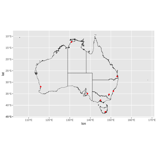<!-- --> ] --- Your turn: Draw the electoral boundaries ```r oz_votes <- rmapshaper::ms_simplify(ozmaps::abs_ced) ``` --- ```r library(ggplot2) library(sf) nc <- sf::st_read(system.file("shape/nc.shp", package = "sf"), quiet = TRUE) point <- data.frame(id = "hi", lat = 36, long = -80) # point inside NC nc ``` ``` ## Simple feature collection with 100 features and 14 fields ## Geometry type: MULTIPOLYGON ## Dimension: XY ## Bounding box: xmin: -84.32385 ymin: 33.88199 xmax: -75.45698 ymax: 36.58965 ## Geodetic CRS: NAD27 ## First 10 features: ## AREA PERIMETER CNTY_ CNTY_ID NAME FIPS FIPSNO CRESS_ID BIR74 SID74 ## 1 0.114 1.442 1825 1825 Ashe 37009 37009 5 1091 1 ## 2 0.061 1.231 1827 1827 Alleghany 37005 37005 3 487 0 ## 3 0.143 1.630 1828 1828 Surry 37171 37171 86 3188 5 ## 4 0.070 2.968 1831 1831 Currituck 37053 37053 27 508 1 ## 5 0.153 2.206 1832 1832 Northampton 37131 37131 66 1421 9 ## 6 0.097 1.670 1833 1833 Hertford 37091 37091 46 1452 7 ## 7 0.062 1.547 1834 1834 Camden 37029 37029 15 286 0 ## 8 0.091 1.284 1835 1835 Gates 37073 37073 37 420 0 ## 9 0.118 1.421 1836 1836 Warren 37185 37185 93 968 4 ## 10 0.124 1.428 1837 1837 Stokes 37169 37169 85 1612 1 ## NWBIR74 BIR79 SID79 NWBIR79 geometry ## 1 10 1364 0 19 MULTIPOLYGON (((-81.47276 3... ## 2 10 542 3 12 MULTIPOLYGON (((-81.23989 3... ## 3 208 3616 6 260 MULTIPOLYGON (((-80.45634 3... ## 4 123 830 2 145 MULTIPOLYGON (((-76.00897 3... ## 5 1066 1606 3 1197 MULTIPOLYGON (((-77.21767 3... ## 6 954 1838 5 1237 MULTIPOLYGON (((-76.74506 3... ## 7 115 350 2 139 MULTIPOLYGON (((-76.00897 3... ## 8 254 594 2 371 MULTIPOLYGON (((-76.56251 3... ## 9 748 1190 2 844 MULTIPOLYGON (((-78.30876 3... ## 10 160 2038 5 176 MULTIPOLYGON (((-80.02567 3... ``` --- .pull-left[ ## Data ```r ggplot() + geom_sf(data = nc) + coord_sf(crs = st_crs(3347)) ``` <!-- --> ] .pull-right[ ## Points ```r ggplot() + geom_sf(data = nc) + geom_point(data = point, aes(x = long, y = lat)) ``` 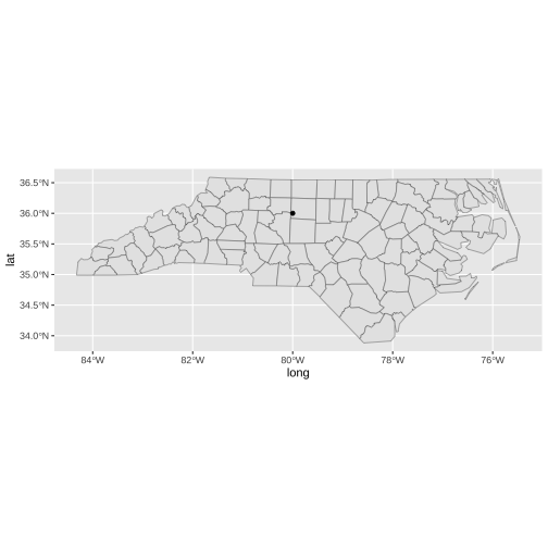<!-- --> ] --- ## Data and Points ```r ggplot() + geom_sf(data = nc) + geom_point(data = point, aes(x = long, y = lat)) + coord_sf(crs = st_crs(3347)) ``` 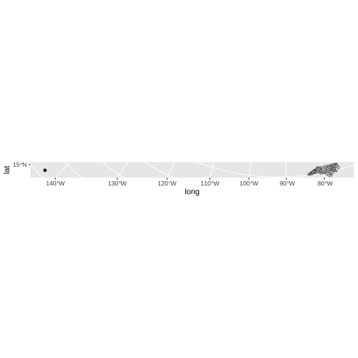<!-- --> --- EPSG:3347 NAD83 / Statistics Canada Lambert **Coordinate Reference System Formats: Three common formats include.** - proj.4 - EPSG - Well-known Text (WKT) formats. --- ```r point <- st_as_sf(point, coords = c("long", "lat"), crs = 4326) ggplot() + geom_sf(data = nc) + geom_sf(data = point) + coord_sf(crs = st_crs(3347)) ``` 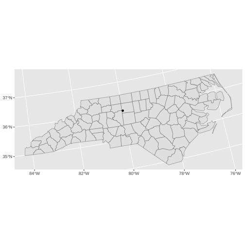<!-- --> `coord_sf` knows what to transform from --- class: center, middle `coord_sf` can convert layers to common projections but they need to be sf objects for it to know how to do so. --- ## Projecting your data ```r library(sf) library(ggplot2) # devtools::install_github("hrbrmstr/albersusa") library(albersusa) ``` ``` ## Please note that 'maptools' will be retired during October 2023, ## plan transition at your earliest convenience (see ## https://r-spatial.org/r/2023/05/15/evolution4.html and earlier blogs ## for guidance);some functionality will be moved to 'sp'. ## Checking rgeos availability: TRUE ``` ``` ## rgeos version: 0.6-4, (SVN revision 699) ## GEOS runtime version: 3.10.2-CAPI-1.16.0 ## Please note that rgeos will be retired during October 2023, ## plan transition to sf or terra functions using GEOS at your earliest convenience. ## See https://r-spatial.org/r/2023/05/15/evolution4.html for details. ## GEOS using OverlayNG ## Linking to sp version: 2.0-0 ## Polygon checking: TRUE ``` --- ```r crs_use = "+proj=laea +lat_0=30 +lon_0=-95" d_points = data.frame(long = c(-110, -103, -84), lat = c(45, 40, 41)) ``` --- ```r A <- ggplot(data = usa_sf()) + geom_sf() + geom_point(data = d_points, aes(x = long, y = lat), color = "red", size = 5) + theme_minimal() + ggtitle("(A) right point position, wrong projection") ``` --- ```r A ``` ``` ## old-style crs object detected; please recreate object with a recent sf::st_crs() ## old-style crs object detected; please recreate object with a recent sf::st_crs() ## old-style crs object detected; please recreate object with a recent sf::st_crs() ``` <!-- --> --- ```r B <- ggplot(data = usa_sf()) + geom_sf() + geom_point(data = d_points, aes(x = long, y = lat), color = "red", size = 5) + coord_sf(crs = crs_use) + theme_minimal() + ggtitle("(B) right projection, wrong points using geom_point()") ``` --- ```r B ``` ``` ## old-style crs object detected; please recreate object with a recent sf::st_crs() ## old-style crs object detected; please recreate object with a recent sf::st_crs() ``` <!-- --> --- ```r C <- ggplot() + geom_sf(data = usa_sf()) + geom_sf(data = st_as_sf(d_points, coords = c("long", "lat"), crs = crs_use), color = "red", size = 5) + coord_sf(crs = crs_use) + theme_minimal() + ggtitle("(C) right projection, wrong points using geom_sf() points") ``` --- ```r C ``` ``` ## old-style crs object detected; please recreate object with a recent sf::st_crs() ``` <!-- --> --- ```r #remotes::install_github("ropensci/USAboundaries") #install.packages("USAboundariesData", repos = "https://ropensci.r-universe.dev", type = "source") library(USAboundaries) library(tidyverse) crs_use <- "+proj=laea +lat_0=30 +lon_0=-95" usa_sf <- us_boundaries(type="state", resolution = "low") %>% dplyr::filter(!state_abbr %in% c("PR", "AK", "HI")) %>% st_transform(crs = crs_use) d_points <- data.frame(long = c(-110, -103, -84), lat = c(45, 40, 41)) %>% st_as_sf(coords = c("long", "lat"), crs = 4326) %>% st_transform(crs = crs_use) D <- ggplot(data = usa_sf) + geom_sf() + geom_sf(data = d_points, color = "red", size = 5) + theme_minimal() ``` --- ```r D ``` ``` ## function (expr, name) ## .External(C_doD, expr, name) ## <bytecode: 0x7fbf8041fc40> ## <environment: namespace:stats> ``` --- `st_as_sf()`: what coordinate system do the coordinates you just gave me use? `st_transform()`: what coordinate system should I transform those coordinates into? **Analogy:** if you were translating a book, the crs in `st_as_sf()` is "what language is the book written in?" `st_transform()` is "what language am I translating this to?" --- ## What does CRS 4326 mean? - The Three Most Common Coordinate Reference Systems - WGS84 and EPSG:4326 are geographic CRS. - It means that they use latitude and longitude coordinates to specify a location on the surface of the earth. --- ## Projecting your data **Additional reading** Click [here](https://www.earthdatascience.org/courses/earth-analytics/spatial-data-r/intro-to-coordinate-reference-systems/) --- ## Interactive chart ```r library(tidyverse) library(sf) library(viridis) #devtools::install_github("tylermorganwall/rayshader") library(rayshader) sightings = st_read(dsn = "~/Dropbox/R Code Repository/Sasquatch/WA_OR_Bigfoot.shp") sightings = mutate(sightings, Sightings = Join_Count) outputFile <- file.path("~/Dropbox/R Code Repository/Sasquatch/", "sasquatch_sightings.mp4") ``` Resources: https://geospatialtraining.com/3d-mapping-of-sasquatch-sightings-in-r-with-rayshader/ --- ```r sightings ``` --- ```r ggSightings <- ggplot(data = sightings) + geom_sf(aes(fill = Sightings)) + scale_fill_viridis("Sightings") + ggtitle("Sasquatch Sightings - Washington and Oregon") + theme_bw() ``` --- ```r ggSightings ``` --- ```r plot_gg(ggSightings,multicore=TRUE,width=5,height=5,scale=250,windowsize=c(1400,866), zoom = 0.55, phi = 30) render_snapshot() render_movie(filename = outputFile) ``` --- class: center, middle # 2. Polygon map --- ```r # devtools::install_github("UrbanInstitute/urbnmapr") library(tidyverse) library(magrittr) ``` ``` ## ## Attaching package: 'magrittr' ``` ``` ## The following object is masked from 'package:raster': ## ## extract ``` ``` ## The following object is masked from 'package:purrr': ## ## set_names ``` ``` ## The following object is masked from 'package:tidyr': ## ## extract ``` ```r library(urbnmapr) library(usmap) # to obtain population data library(ggthemes) library(scales) ``` ``` ## ## Attaching package: 'scales' ``` ``` ## The following object is masked from 'package:viridis': ## ## viridis_pal ``` ``` ## The following object is masked from 'package:purrr': ## ## discard ``` ``` ## The following object is masked from 'package:readr': ## ## col_factor ``` ```r library(geofacet) ``` --- ```r statepop1 <- statepop %>% rename(state_name = full) statepop2 <- full_join(statepop1, states, by = "state_name") head(statepop2) ``` ``` ## # A tibble: 6 × 12 ## fips abbr state_name pop_2015 long lat order hole piece group state_fips ## <chr> <chr> <chr> <dbl> <dbl> <dbl> <int> <lgl> <fct> <fct> <chr> ## 1 01 AL Alabama 4858979 -88.5 31.9 1 FALSE 1 01.1 01 ## 2 01 AL Alabama 4858979 -88.5 31.9 2 FALSE 1 01.1 01 ## 3 01 AL Alabama 4858979 -88.5 31.9 3 FALSE 1 01.1 01 ## 4 01 AL Alabama 4858979 -88.5 32.0 4 FALSE 1 01.1 01 ## 5 01 AL Alabama 4858979 -88.5 32.0 5 FALSE 1 01.1 01 ## 6 01 AL Alabama 4858979 -88.5 32.1 6 FALSE 1 01.1 01 ## # ℹ 1 more variable: state_abbv <chr> ``` --- ```r ggplot() + geom_point(data = statepop2, mapping = aes(x = long, y = lat, group = group), fill = "grey", color = "black") ``` <!-- --> --- ```r ggplot() + geom_polygon(data = statepop2, mapping = aes(x = long, y = lat, group = group),fill = "grey", color = "black") ``` <!-- --> --- Visit here: https://tstdataviz.netlify.app/slides/spatiotemporal.html --- # Moving forward ### Visualizing using webmaps ```r library(leaflet) ``` ### Visualization of raster data ```r library(raster) ``` ---